


Ram Head Trail — St. John's #1 Hike
A 2.3-mile roundtrip hike to the southernmost point of St. John, with dramatic cliff views, unique cactus landscapes, and 360° ocean panoramas. Rated 4.8★ on AllTrails with 1,400+ reviews.
Trail at a Glance
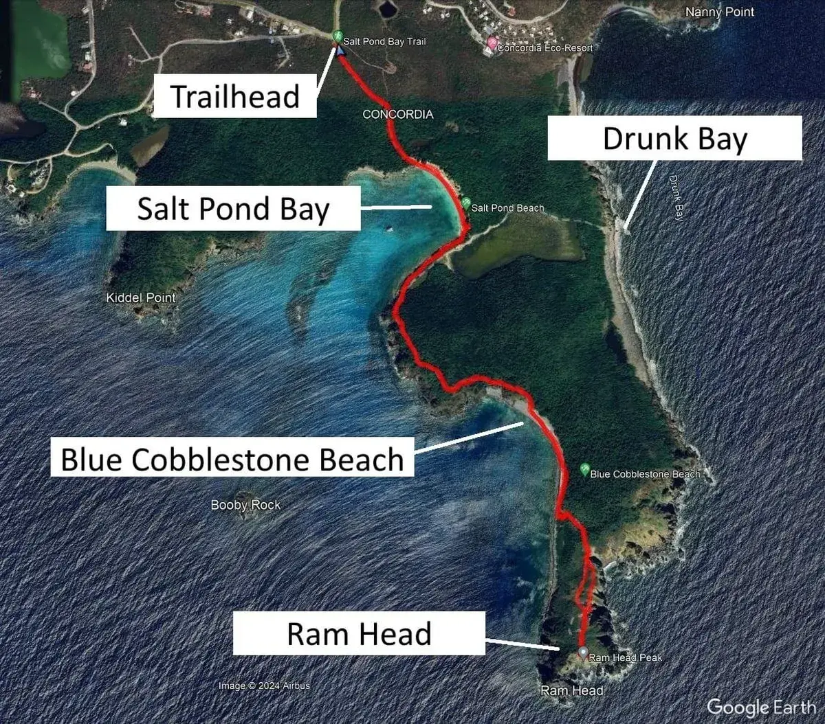
Trail Map
The trail starts at Salt Pond Bay parking and follows the coastline south to the Ram Head peninsula
Getting There
From Cruz Bay (35 min drive)
Take Route 107 South through the Virgin Islands National Park. The drive is scenic and quiet — you'll pass through Coral Bay and several small towns. Salt Pond Bay parking is at the end of the road.
From St. Thomas (ferry + drive)
Take the Red Hook to Cruz Bay ferry (20 min, ~$7). From Cruz Bay, rent a jeep or take a taxi. The car ferry (Big Red Barge) lets you bring your rental car over — departs at 8:30 AM and arrives by 9:00 AM.
Parking
Small free lot at Salt Pond Bay shared with beachgoers. Arrives early (before 9 AM) for best spots. No overflow parking available. Alternatively, take a taxi from Cruz Bay or Coral Bay.
Section-by-Section Trail Guide
Salt Pond Bay Parking to Beach
From the small parking lot, follow the dirt path downhill to Salt Pond Bay Beach. The path is rocky but well-trodden. You'll pass a small restroom facility — the only one on the entire trail. At the bottom, you'll reach a peaceful cove with calm, shallow water.
Salt Pond Beach Crossing
Walk across Salt Pond Bay Beach in your hiking shoes — you'll pass sunbathers and snorkelers. At the far end, look for the trail sign pointing toward Drunk Bay and Ram Head. Stay right toward Ram Head.
Coastal Trail to Blue Cobblestone Beach
This is one of the most scenic sections — the rocky path follows the coastline with views of the turquoise cove to your right. You'll walk through a mix of sun and shade before entering a wooded section. At a fork, take the left path and descend to Blue Cobblestone Beach.
Blue Cobblestone Beach
A unique beach made entirely of smooth, rounded-sm cobblestones — some as large as bowling balls. Walking is awkward but fun. Cross to the far side and look for a small 'trail' sign in the rocks pointing uphill. This marks the start of the Ram Head ascent.
Ram Head Ascent & Summit
The steepest section of the trail climbs through a landscape dominated by barrel cacti (melocactus) and turk's cap cacti. The views expand dramatically with each step — you can see both sides of the peninsula. The summit is a large, open rocky area with 360-degree views of the Caribbean Sea, St. Croix (on clear days), and the cactus-studded hillside below. It's incredibly windy at the top.
When to Hike Ram Head Trail
Best Time of Day
Early morning (7–9 AM) for coolest temperatures, or late afternoon for sunset views. Avoid 11 AM–2 PM — the summit has zero shade.
Best Season
December through April — dry weather, cooler temperatures, and clearest ocean visibility. Avoid hurricane season (Aug–Oct).
Best for Photos
Golden hour before sunset gives the most dramatic lighting on the cliffs. Morning light is best for views looking southeast toward St. Croix.
What to Bring
✓ Must Have
- ✓ 1+ liter water per person (minimum)
- ✓ Reef-safe sunscreen SPF 50+
- ✓ Wide-brim hat and sunglasses
- ✓ Sturdy closed-toe shoes
- ✓ Swimsuit and towel (for Salt Pond Bay)
- ✓ Camera or phone
✗ Don't Bring / Don't Do
- ✗ Drones (prohibited in National Park)
- ✗ Flip-flops (rocky terrain, especially at summit)
- ✗ Only a small water bottle (you need more)
- ✗ Leave trash anywhere on the trail
- ✗ Feed or approach wild goats
- ✗ Hike after dark (no lighting on trail)
Warning: Watch out for sand stickers (small spiny seeds) near the grass at Salt Pond Bay Beach. They blend into the sand and are painful to step on barefoot.