

Virgin Islands National Park
Over 7,259 acres of protected tropical forest, pristine beaches, coral reefs, and 18th-century sugar plantation ruins — two-thirds of St. John is National Park. Established in 1956 after Laurance Rockefeller donated the land.
The only Caribbean national park accessible by ferry. 20+ hiking trails, 6 world-class snorkel spots, and 3,000 years of human history.
Hours
Open 24/7 — Visitor Center 8:30am–4:30pm
Entry Fee
Free (Trunk Bay: $5/person)
Emergency
911 or (340) 776-6201
Size
7,259 acres + 5,650 underwater
St. John Hiking Trail Map
27 numbered trails across the North and South shores — from 10-minute walks to 2-hour backcountry treks. Reference this map alongside the trail directory below.
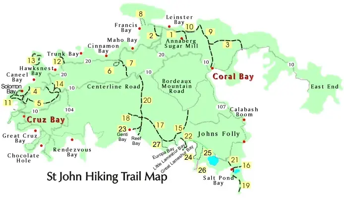
For current trail conditions, check with rangers at the Cruz Bay Visitor Center or visit nps.gov/viis.
North Shore Trails
South Shore Trails
Best Hiking Trails
From 20-minute nature walks to rugged coastal treks — every fitness level is covered.
Reef Bay Trail
ModerateThe park's signature hike descends 1,000 feet through tropical dry and moist forest to a sugar mill ruin and Reef Bay beach. At mile 1.8, a spur leads to Taíno petroglyphs — ancient rock carvings above a freshwater pool, created 600–1,500 years ago. NPS ranger-led hikes ($30) include a boat ride back to Cruz Bay.
Ram Head Trail
ModerateA rugged coastal trail starting at Salt Pond Bay that climbs to a dramatic 200-foot cliff overlooking the Caribbean. The final approach crosses exposed rock dotted with Turk's cap cacti — some over 100 years old. Best at sunrise or sunset.
Lind Point Trail
EasyStarts directly behind the Cruz Bay Visitor Center — the most accessible trail in the park. Leads to panoramic views of Pillsbury Sound and St. Thomas, then continues down to Honeymoon Beach and Salomon Bay.
Cinnamon Bay Loop
EasyA short, flat loop through sugar plantation ruins and tropical forest. Interpretive signs explain the archaeology — pre-Columbian Taíno artifacts dating back 1,000+ years have been found here, making it one of the oldest known settlement sites in the Caribbean.
Johnny Horn Trail
Moderate–DifficultConnects Coral Bay to Waterlemon Cay via the island's rugged east end. Less trafficked and more adventurous — passes through cactus scrub, dry forest, and old Danish road traces. Ends at the best snorkeling in the park.
Francis Bay Trail
EasyA short boardwalk through a salt pond ecosystem — prime birdwatching territory for herons, pelicans, ospreys, and migrating shorebirds. Connects to the peaceful Francis Bay beach.
Best Snorkel Spots
Ranked by reef quality, marine life diversity, and overall experience. St. John protects 5,650 acres of underwater habitat — some of the healthiest reef remaining in the Caribbean.
Waterlemon Cay
★★★★★Widely considered the best snorkeling in the USVI. Swim 200 yards from the Leinster Bay beach to the cay and circle it clockwise. Sea turtles, nurse sharks, spotted eagle rays, barracuda, and vibrant coral gardens. The reef on the north side is the healthiest. Arrive before 10am for calm water and fewer boats.
Trunk Bay Underwater Trail
★★★★☆The only marked underwater snorkel trail in the NPS system — 225 yards with labeled signs identifying coral and fish species. Perfect for beginners and families. The reef has been impacted by storms and bleaching but is recovering. $5 NPS entry fee includes beach access and lifeguards.
Haulover Bay
★★★★★No crowds, no fee, and healthy reef right off the beach. Green sea turtles frequent the seagrass beds on the south side. Short hike from the East End parking area. The reef at the bay's north point has excellent brain coral and sea fans.
Maho Bay
★★★★☆The most reliable sea turtle sighting in the USVI — green turtles graze on seagrass daily, especially mornings. Shallow, calm, and perfect for kids and beginners. Free entry, usually easy parking. The beach also offers kayak and paddleboard rentals.
Salt Pond Bay
★★★★☆A 10-minute downhill hike to the beach. The reef on the left (east) side is rich with sea fans, parrotfish, and occasional octopus. Continue past the salt pond to Drunk Bay for dramatic wave-battered shoreline, or hike to Ram Head for cliffside views.
Henley Cay
★★★★★Accessible only by kayak or charter — dramatic wall snorkeling with elkhorn coral colonies (critically endangered), barracuda, and dense schools of blue tang. The west wall drops to 40+ feet with excellent visibility. One of the few places to see healthy elkhorn coral in the USVI.
Off the Beaten Path
Beyond the guidebook — places most visitors miss entirely. These are the spots locals recommend.
Annaberg Sugar Plantation
The best-preserved 18th-century sugar mill ruins in the USVI, overlooking Leinster Bay and the British Virgin Islands. Free self-guided tour with interpretive signs detailing the brutal history of enslaved labor on Danish sugar plantations. The windmill, horsemill, and slave quarters are still standing. Cultural demonstrations are held periodically.
Built circa 1780. Listed on the National Register of Historic Places.
Reef Bay Petroglyphs
Ancient Taíno rock carvings at a freshwater pool along the Reef Bay Trail. The petroglyphs include faces with headdresses, geometric patterns, and symbols believed to relate to water and ancestral spirits. Created between 600–1,500 years ago by the Taíno people, the Caribbean's original inhabitants. Book the NPS ranger-led hike ($30) for the full interpretation — they ferry you back by boat.
Listed on the National Register of Historic Places since 1976.
Peace Hill Windmill
A 5-minute walk from the North Shore Road to a Danish windmill ruin (built ~1780) with unobstructed 360° views of St. Thomas, Jost Van Dyke, Hawksnest Bay, and the BVI. Free, uncrowded, and the best sunset spot on St. John. The original windmill powered a sugarcane press.
Destroyed by Hurricane Marilyn in 1995 — the stone base remains.
Fortsberg (1733 Akwamu Revolt)
The site of the 1733 Akwamu Insurrection — the first major slave revolt in the Caribbean. On November 23, 1733, enslaved Akwamu people seized this Danish fort in Coral Bay, controlling most of St. John for six months before French troops from Martinique crushed the rebellion. NPS added interpretive signage in 2023 to honor this history. The overlook above Coral Bay is powerful.
National Register of Historic Places. Fort rebuilt 1760.
Brown Bay Trail
Rarely hiked 1.6-mile trail through dry forest to a completely secluded beach on the island's remote east end. You'll likely have the entire bay to yourself. Access from the Johnny Horn Trail junction near East End Road.
No facilities, no crowds, no cell service.
Denis Bay
Accessible only by boat or a steep unmarked trail from the North Shore Road near Peace Hill. A crescent of white sand with zero facilities, zero crowds, and zero development. True off-the-grid beach. If you charter a boat, ask your captain to anchor here.
Former plantation land, now fully within park boundaries.
History & Conservation
3,000 Years of Human History
- ~600 AD: Taíno people settle St. John, leaving petroglyphs at Reef Bay and artifacts at Cinnamon Bay — one of the oldest known sites in the Caribbean.
- 1718: Danish West India Company colonizes St. John, establishing sugar plantations worked by enslaved Africans.
- 1733: The Akwamu Insurrection — 150 enslaved people seize Fortsberg and control St. John for six months, the first major slave revolt in the Caribbean.
- 1848: Emancipation in the Danish West Indies. Plantation economy collapses.
- 1917: United States purchases the Virgin Islands from Denmark for $25 million.
- 1956: Laurance Rockefeller donates 5,000 acres to the NPS, establishing Virgin Islands National Park.
Active Conservation Efforts
- Coral Restoration: NPS treats Stony Coral Tissue Loss Disease (SCTLD) with amoxicillin across 25 coral species. Staghorn and elkhorn coral nurseries are cultivated for reef replanting.
- Turtle Monitoring: Green and hawksbill sea turtle nesting sites are monitored annually. Maho Bay's seagrass beds are a critical feeding ground.
- Mangrove Restoration: Post-hurricane mangrove replanting protects shorelines and provides nursery habitat for reef fish.
- Reef-Safe Sunscreen: The USVI banned oxybenzone and octinoxate sunscreens in 2020 to protect coral. Use mineral-based sunscreen with zinc oxide.
- Invasive Species: Mongoose and green iguanas are managed to protect native birds and sea turtle eggs.